Make a donation
Gear up for your next adventure:
As an Amazon Associate, this site earns from qualifying purchases at no extra cost to you.
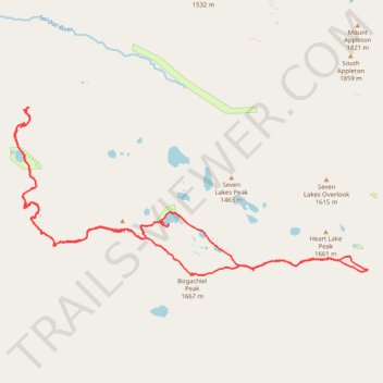
High Divide Trail
- Distance: 16.4 mi
- Elevation gain: 4,459 ft
- Maximum elevation: 5,390 ft
- Elevation loss: 4,452 ft
- Minimum elevation: 3,035 ft
Interactive trail map
Make a donation
Gear up for your next adventure:
As an Amazon Associate, this site earns from qualifying purchases at no extra cost to you.
Trail profile
- Distance: 16.4 mi
- Elevation gain: 4,459 ft
- Maximum elevation: 5,390 ft
- Elevation loss: 4,452 ft
- Minimum elevation: 3,035 ft
Make a donation
Gear up for your next adventure:
As an Amazon Associate, this site earns from qualifying purchases at no extra cost to you.
About this trail
Name: High Divide Trail trail, distance, elevation, map, profile, GPS track
Start: Deer Lake Trail, Clallam County, Washington, United States (47.93550 -123.82148)
Coordinates: 47.90507 -123.82545 47.93553 -123.73004
Topography: Clallam County topographic map, elevation, terrain
Make a donation
Gear up for your next adventure:
As an Amazon Associate, this site earns from qualifying purchases at no extra cost to you.
Other hiking, mountain biking, running and outdoor activity trails
Click on a trail to view its statistics, map and profile.
Deer Lake Trail via Sol Duc Falls
United States > Washington > Clallam County
Distance: 2.5 mi • Elevation gain: 1,211 ft • Maximum elevation: 3,051 ft