Thank you for supporting this site ❤️
Make a donation
Make a donation
Gear up for your next adventure:
As an Amazon Associate, this site earns from qualifying purchases at no extra cost to you.
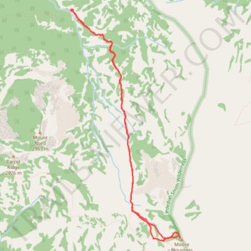
Moose Mountain via Teton Crest Trail
- Distance: 5.8 mi
- Elevation gain: 1,949 ft
- Maximum elevation: 10,000 ft
- Elevation loss: 1,955 ft
- Minimum elevation: 8,061 ft
- Moving time: 2 h 39 m
- Moving speed: 2.2 mph
- Maximum speed: 5.3 mph
- Total time: 3 h 34 m
- Global speed: 1.6 mph
Interactive trail map
Thank you for supporting this site ❤️
Make a donation
Make a donation
Gear up for your next adventure:
As an Amazon Associate, this site earns from qualifying purchases at no extra cost to you.
Trail profile
- Distance: 5.8 mi
- Elevation gain: 1,949 ft
- Maximum elevation: 10,000 ft
- Elevation loss: 1,955 ft
- Minimum elevation: 8,061 ft
- Moving time: 2 h 39 m
- Moving speed: 2.2 mph
- Maximum speed: 5.3 mph
- Total time: 3 h 34 m
- Global speed: 1.6 mph
Thank you for supporting this site ❤️
Make a donation
Make a donation
Gear up for your next adventure:
As an Amazon Associate, this site earns from qualifying purchases at no extra cost to you.
About this trail
Name: Moose Mountain via Teton Crest Trail trail, distance, elevation, map, profile, GPS track
Start: Carrot Ridge Trail, Teton County, Wyoming, United States (43.96730 -110.87630)
End: Carrot Ridge Trail, Teton County, Wyoming, United States (43.96712 -110.87629)
Coordinates: 43.93715 -110.87635 43.96731 -110.85660
Topography: Teton County topographic map, elevation, terrain
Thank you for supporting this site ❤️
Make a donation
Make a donation
Gear up for your next adventure:
As an Amazon Associate, this site earns from qualifying purchases at no extra cost to you.