Thank you for supporting this site ❤️
Make a donation
Make a donation
Gear up for your next adventure:
As an Amazon Associate, this site earns from qualifying purchases at no extra cost to you.
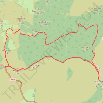
Hungry Law Loop From Parking
- Distance: 11.9 mi
- Elevation gain: 1,624 ft
- Maximum elevation: 1,627 ft
- Elevation loss: 1,624 ft
- Minimum elevation: 791 ft
- Moving time: 4 h 22 m
- Moving speed: 2.7 mph
- Maximum speed: 6.5 mph
- Total time: 5 h 8 m
- Global speed: 2.3 mph
Interactive trail map
Thank you for supporting this site ❤️
Make a donation
Make a donation
Gear up for your next adventure:
As an Amazon Associate, this site earns from qualifying purchases at no extra cost to you.
Trail profile
- Distance: 11.9 mi
- Elevation gain: 1,624 ft
- Maximum elevation: 1,627 ft
- Elevation loss: 1,624 ft
- Minimum elevation: 791 ft
- Moving time: 4 h 22 m
- Moving speed: 2.7 mph
- Maximum speed: 6.5 mph
- Total time: 5 h 8 m
- Global speed: 2.3 mph
Thank you for supporting this site ❤️
Make a donation
Make a donation
Gear up for your next adventure:
As an Amazon Associate, this site earns from qualifying purchases at no extra cost to you.
About this trail
Name: Hungry Law Loop From Parking trail, distance, elevation, map, profile, GPS track
Start: A68, Scottish Borders, Scotland, TD8 6PT, United Kingdom (55.35468 -2.47762)
End: A68, Scottish Borders, Scotland, TD8 6PT, United Kingdom (55.35466 -2.47763)
Coordinates: 55.34870 -2.47877 55.37493 -2.39954
Thank you for supporting this site ❤️
Make a donation
Make a donation
Gear up for your next adventure:
As an Amazon Associate, this site earns from qualifying purchases at no extra cost to you.