Thank you for supporting this site ❤️
Make a donation
Make a donation
Gear up for your next adventure:
As an Amazon Associate, this site earns from qualifying purchases at no extra cost to you.
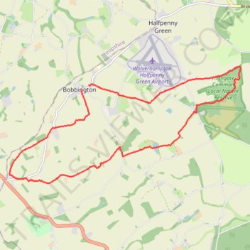
Bobbington circular walk all on public foot paths
- Distance: 8.4 mi
- Elevation gain: 430 ft
- Maximum elevation: 512 ft
- Elevation loss: 433 ft
- Minimum elevation: 266 ft
- Moving time: 3 h 1 m
- Moving speed: 2.8 mph
- Maximum speed: 4.5 mph
- Total time: 3 h 58 m
- Global speed: 2.1 mph
Interactive trail map
Thank you for supporting this site ❤️
Make a donation
Make a donation
Gear up for your next adventure:
As an Amazon Associate, this site earns from qualifying purchases at no extra cost to you.
Trail profile
- Distance: 8.4 mi
- Elevation gain: 430 ft
- Maximum elevation: 512 ft
- Elevation loss: 433 ft
- Minimum elevation: 266 ft
- Moving time: 3 h 1 m
- Moving speed: 2.8 mph
- Maximum speed: 4.5 mph
- Total time: 3 h 58 m
- Global speed: 2.1 mph
Thank you for supporting this site ❤️
Make a donation
Make a donation
Gear up for your next adventure:
As an Amazon Associate, this site earns from qualifying purchases at no extra cost to you.
About this trail
Name: Bobbington circular walk all on public foot paths trail, distance, elevation, map, profile, GPS track
Coordinates: 52.49390 -2.30697 52.51620 -2.23423
Thank you for supporting this site ❤️
Make a donation
Make a donation
Gear up for your next adventure:
As an Amazon Associate, this site earns from qualifying purchases at no extra cost to you.