Make a donation
Gear up for your next adventure:
As an Amazon Associate, this site earns from qualifying purchases at no extra cost to you.
26 June 2026 at 2:56 pm
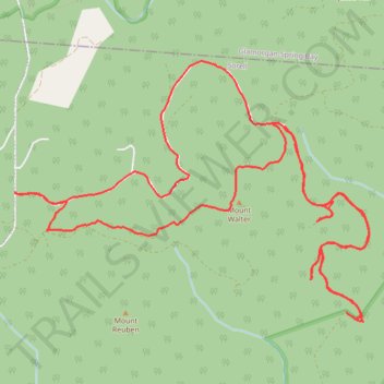
- Distance: 10.6 mi
- Elevation gain: 2,054 ft
- Maximum elevation: 1,732 ft
- Elevation loss: 2,047 ft
- Minimum elevation: 722 ft
- Moving time: 3 h 40 m
- Moving speed: 2.9 mph
- Maximum speed: 5.0 mph
- Total time: 5 h 2 m
- Global speed: 2.1 mph
Interactive trail map
Make a donation
Gear up for your next adventure:
As an Amazon Associate, this site earns from qualifying purchases at no extra cost to you.
Trail profile
- Distance: 10.6 mi
- Elevation gain: 2,054 ft
- Maximum elevation: 1,732 ft
- Elevation loss: 2,047 ft
- Minimum elevation: 722 ft
- Moving time: 3 h 40 m
- Moving speed: 2.9 mph
- Maximum speed: 5.0 mph
- Total time: 5 h 2 m
- Global speed: 2.1 mph
Make a donation
Gear up for your next adventure:
As an Amazon Associate, this site earns from qualifying purchases at no extra cost to you.
About this trail
Name: 26 June 2026 at 2:56 pm trail, distance, elevation, map, profile, GPS track
Start: Wielangta Road, Bream Creek, Buckland, Tasmania, 7190, Australia (-42.72732 147.84011)
End: Bream Creek, Tasmania, 7175, Australia (-42.72717 147.84021)
Coordinates: -42.73823 147.84008 -42.71616 147.88086
Make a donation
Gear up for your next adventure:
As an Amazon Associate, this site earns from qualifying purchases at no extra cost to you.
Other hiking, mountain biking, running and outdoor activity trails
Click on a trail to view its statistics, map and profile.
HELLFIRE7 04:43:17 PM
Australia > Tasmania > Bream Creek
Distance: 7.6 mi • Elevation gain: 1,811 ft • Maximum elevation: 1,503 ft