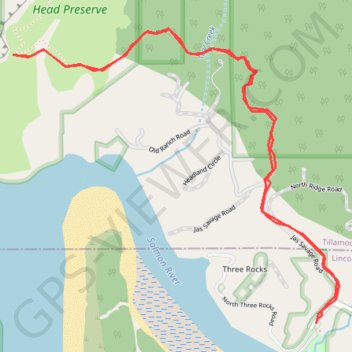
Cascade Head Viewpoint
Hike from Knight County Park to Lower Cascade Head Viewpoint in the Cascade Head Preserve and the Siuslaw National Forest. #Hiking #Nature #Coast #Sea #Ocean #Pacific #Forest
- Distance: 3.3 mi
- Elevation gain: 804 ft
- Maximum elevation: 587 ft
- Elevation loss: 814 ft
- Minimum elevation: 23 ft
- Moving time: 1 h 55 m
- Moving speed: 1.7 mph
- Maximum speed: 2.9 mph
- Total time: 1 h 55 m
- Global speed: 1.7 mph
Interactive trail map
Trail profile
- Distance: 3.3 mi
- Elevation gain: 804 ft
- Maximum elevation: 587 ft
- Elevation loss: 814 ft
- Minimum elevation: 23 ft
- Moving time: 1 h 55 m
- Moving speed: 1.7 mph
- Maximum speed: 2.9 mph
- Total time: 1 h 55 m
- Global speed: 1.7 mph
About this trail
Name: Cascade Head Viewpoint trail, distance, elevation, map, profile, GPS track
Coordinates: 45.04190 -124.00887 45.05325 -123.99112
Topography: Lincoln County topographic map, elevation, terrain