Thank you for supporting this site ❤️
Make a donation
Make a donation
Gear up for your next adventure:
As an Amazon Associate, this site earns from qualifying purchases at no extra cost to you.
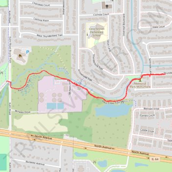
Klein Creek Trail
- Distance: 1.5 mi
- Elevation gain: 20 ft
- Maximum elevation: 761 ft
- Elevation loss: 16 ft
- Minimum elevation: 745 ft
- Moving time: 33 m 30 s
- Moving speed: 2.8 mph
- Maximum speed: 5.1 mph
- Total time: 1 h 1 m
- Global speed: 1.5 mph
Interactive trail map
Thank you for supporting this site ❤️
Make a donation
Make a donation
Gear up for your next adventure:
As an Amazon Associate, this site earns from qualifying purchases at no extra cost to you.
Trail profile
- Distance: 1.5 mi
- Elevation gain: 20 ft
- Maximum elevation: 761 ft
- Elevation loss: 16 ft
- Minimum elevation: 745 ft
- Moving time: 33 m 30 s
- Moving speed: 2.8 mph
- Maximum speed: 5.1 mph
- Total time: 1 h 1 m
- Global speed: 1.5 mph
Thank you for supporting this site ❤️
Make a donation
Make a donation
Gear up for your next adventure:
As an Amazon Associate, this site earns from qualifying purchases at no extra cost to you.
About this trail
Name: Klein Creek Trail trail, distance, elevation, map, profile, GPS track
Coordinates: 41.90847 -88.14046 41.91033 -88.12772
Topography: DuPage County topographic map, elevation, terrain
Thank you for supporting this site ❤️
Make a donation
Make a donation
Gear up for your next adventure:
As an Amazon Associate, this site earns from qualifying purchases at no extra cost to you.