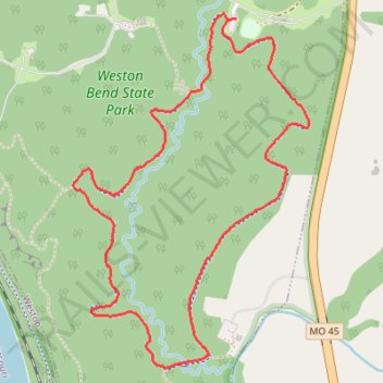
Weston Bend State Park Paved Loop
- Distance: 2.8 mi
- Elevation gain: 272 ft
- Maximum elevation: 919 ft
- Elevation loss: 276 ft
- Minimum elevation: 787 ft
- Moving time: 55 m 23 s
- Moving speed: 3.0 mph
- Maximum speed: 4.5 mph
- Total time: 56 m 36 s
- Global speed: 3.0 mph
Interactive trail map
Trail profile
- Distance: 2.8 mi
- Elevation gain: 272 ft
- Maximum elevation: 919 ft
- Elevation loss: 276 ft
- Minimum elevation: 787 ft
- Moving time: 55 m 23 s
- Moving speed: 3.0 mph
- Maximum speed: 4.5 mph
- Total time: 56 m 36 s
- Global speed: 3.0 mph
About this trail
Name: Weston Bend State Park Paved Loop trail, distance, elevation, map, profile, GPS track
Coordinates: 39.38021 -94.87588 39.39248 -94.86531
Topography: Platte County topographic map, elevation, terrain