Make a donation
Gear up for your next adventure:
As an Amazon Associate, this site earns from qualifying purchases at no extra cost to you.
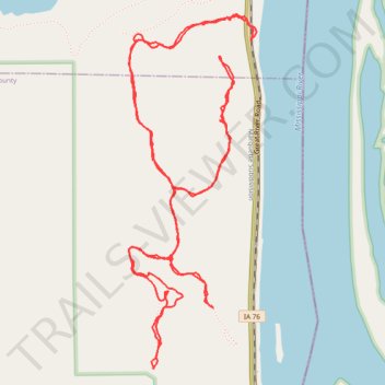
Effigy Mounds National Monument
- Distance: 5.9 mi
- Elevation gain: 755 ft
- Maximum elevation: 1,089 ft
- Elevation loss: 768 ft
- Minimum elevation: 630 ft
- Moving time: 2 h 14 m
- Moving speed: 2.6 mph
- Maximum speed: 5.1 mph
- Total time: 2 h 39 m
- Global speed: 2.2 mph
Interactive trail map
Make a donation
Gear up for your next adventure:
As an Amazon Associate, this site earns from qualifying purchases at no extra cost to you.
Trail profile
- Distance: 5.9 mi
- Elevation gain: 755 ft
- Maximum elevation: 1,089 ft
- Elevation loss: 768 ft
- Minimum elevation: 630 ft
- Moving time: 2 h 14 m
- Moving speed: 2.6 mph
- Maximum speed: 5.1 mph
- Total time: 2 h 39 m
- Global speed: 2.2 mph
Make a donation
Gear up for your next adventure:
As an Amazon Associate, this site earns from qualifying purchases at no extra cost to you.
About this trail
Name: Effigy Mounds National Monument trail, distance, elevation, map, profile, GPS track
Start: Great River Road, Allamakee County, Iowa, 52158, United States (43.08150 -91.18048)
End: Great River Road, Allamakee County, Iowa, 52158, United States (43.08155 -91.18043)
Coordinates: 43.06637 -91.18818 43.08272 -91.18016
Topography: Allamakee County topographic map, elevation, terrain
Make a donation
Gear up for your next adventure:
As an Amazon Associate, this site earns from qualifying purchases at no extra cost to you.
Other hiking, mountain biking, running and outdoor activity trails
Click on a trail to view its statistics, map and profile.
Hike on the Marching Bear Group and Founder's Pond Overlook Trails at Effigy Mounds NM
United States > Iowa > Allamakee County
Distance: 5.5 mi • Elevation gain: 827 ft • Maximum elevation: 1,089 ft