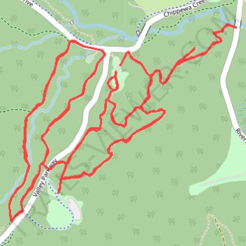
My Mountain, White Oak, Bridal and Deer Lick trails in Brecksville Reservation
A merge of 2 or more activities
- Distance: 7.6 mi
- Elevation gain: 771 ft
- Maximum elevation: 814 ft
- Elevation loss: 774 ft
- Minimum elevation: 650 ft
- Moving time: 1 h 30 m
- Moving speed: 5.0 mph
- Maximum speed: 8.2 mph
- Total time: 1 h 30 m
- Global speed: 5.0 mph
Interactive trail map
Trail profile
- Distance: 7.6 mi
- Elevation gain: 771 ft
- Maximum elevation: 814 ft
- Elevation loss: 774 ft
- Minimum elevation: 650 ft
- Moving time: 1 h 30 m
- Moving speed: 5.0 mph
- Maximum speed: 8.2 mph
- Total time: 1 h 30 m
- Global speed: 5.0 mph
About this trail
Name: My Mountain, White Oak, Bridal and Deer Lick trails in Brecksville Reservation trail, distance, elevation, map, profile, GPS track
Start: Salamander Trail, Brecksville, Cuyahoga County, Ohio, 44141, United States (41.31514 -81.59937)
End: Salamander Trail, Brecksville, Cuyahoga County, Ohio, 44141, United States (41.31515 -81.59935)
Coordinates: 41.30792 -81.60622 41.31706 -81.59216
Topography: Cuyahoga County topographic map, elevation, terrain