Katie, Jack's Ridge, Black House Branch, Station Camp Creek and Duncan Hollow Trails
Big South Fork National River and Recreation Area
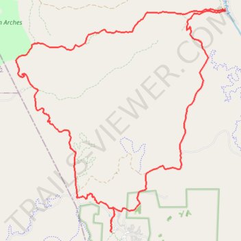
- Distance: 16.2 mi
- Elevation gain: 1,824 ft
- Maximum elevation: 1,598 ft
- Elevation loss: 1,821 ft
- Minimum elevation: 837 ft
Interactive trail map
Trail profile
- Distance: 16.2 mi
- Elevation gain: 1,824 ft
- Maximum elevation: 1,598 ft
- Elevation loss: 1,821 ft
- Minimum elevation: 837 ft
About this trail
Name: Katie, Jack's Ridge, Black House Branch, Station Camp Creek and Duncan Hollow Trails trail, distance, elevation, map, profile, GPS track
Start: Scott County, East Tennessee, Tennessee, United States (36.48913 -84.70226)
End: Scott County, East Tennessee, Tennessee, United States (36.48920 -84.70212)
Coordinates: 36.48910 -84.73306 36.54664 -84.66579
Topography: Scott County topographic map, elevation, terrain
Other hiking, mountain biking, running and outdoor activity trails
Click on a trail to view its statistics, map and profile.
Big Island Loop - Cumberland River South Fork
United States > Tennessee > Scott County
Scott County Dia
Distance: 11.7 mi • Elevation gain: 1,322 ft • Maximum elevation: 1,483 ft
Big South Fork National River and Recreation Area
United States > Tennessee > Scott County
Scott County Dia
Distance: 18.1 mi • Elevation gain: 2,192 ft • Maximum elevation: 1,598 ft
John Litton Farm Hike Loop
United States > Tennessee > Scott County
Scott State Forest, Fall Branch, Scott County Trail Running
Distance: 4.7 mi • Elevation gain: 522 ft • Maximum elevation: 1,578 ft
Cumberland Valley Loop Trail
United States > Tennessee > Fentress County
Fentress County Dia
Distance: 18.2 mi • Elevation gain: 1,683 ft • Maximum elevation: 1,591 ft