Make a donation
Gear up for your next adventure:
As an Amazon Associate, this site earns from qualifying purchases at no extra cost to you.
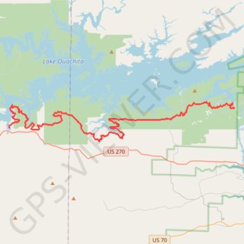
Lake Ouachita Vista Trail (LOViT)
Mountain Bike on Lake Ouachita Vista Trail via Ouachita National Forest. #MTB #Lake #Forest #Nature
- Distance: 36.9 mi
- Elevation gain: 4,439 ft
- Maximum elevation: 1,289 ft
- Elevation loss: 4,564 ft
- Minimum elevation: 466 ft
- Moving time: 6 h 37 m
- Moving speed: 5.6 mph
- Maximum speed: 14.0 mph
- Total time: 6 h 37 m
- Global speed: 5.6 mph
Interactive trail map
Make a donation
Gear up for your next adventure:
As an Amazon Associate, this site earns from qualifying purchases at no extra cost to you.
Trail profile
- Distance: 36.9 mi
- Elevation gain: 4,439 ft
- Maximum elevation: 1,289 ft
- Elevation loss: 4,564 ft
- Minimum elevation: 466 ft
- Moving time: 6 h 37 m
- Moving speed: 5.6 mph
- Maximum speed: 14.0 mph
- Total time: 6 h 37 m
- Global speed: 5.6 mph
Make a donation
Gear up for your next adventure:
As an Amazon Associate, this site earns from qualifying purchases at no extra cost to you.
About this trail
Name: Lake Ouachita Vista Trail (LOViT) trail, distance, elevation, map, profile, GPS track
End: 1309, Blakely Dam Road, Garland County, Arkansas, 71968, United States (34.56673 -93.19506)
Coordinates: 34.53189 -93.48127 34.57273 -93.19506
Topography: Montgomery County topographic map, elevation, terrain
Make a donation
Gear up for your next adventure:
As an Amazon Associate, this site earns from qualifying purchases at no extra cost to you.