Thank you for supporting this site ❤️
Make a donation
Make a donation
Gear up for your next adventure:
As an Amazon Associate, this site earns from qualifying purchases at no extra cost to you.
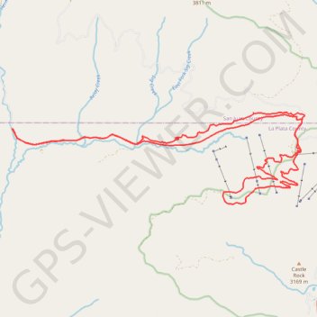
Shangri-la and Cutthroat, Hermosa Park, CO
- Distance: 20.0 mi
- Elevation gain: 2,359 ft
- Maximum elevation: 10,669 ft
- Elevation loss: 2,359 ft
- Minimum elevation: 8,885 ft
- Moving time: 2 h 39 m
- Moving speed: 7.5 mph
- Maximum speed: 26.4 mph
- Total time: 3 h 19 m
- Global speed: 6.0 mph
Interactive trail map
Thank you for supporting this site ❤️
Make a donation
Make a donation
Gear up for your next adventure:
As an Amazon Associate, this site earns from qualifying purchases at no extra cost to you.
Trail profile
- Distance: 20.0 mi
- Elevation gain: 2,359 ft
- Maximum elevation: 10,669 ft
- Elevation loss: 2,359 ft
- Minimum elevation: 8,885 ft
- Moving time: 2 h 39 m
- Moving speed: 7.5 mph
- Maximum speed: 26.4 mph
- Total time: 3 h 19 m
- Global speed: 6.0 mph
Thank you for supporting this site ❤️
Make a donation
Make a donation
Gear up for your next adventure:
As an Amazon Associate, this site earns from qualifying purchases at no extra cost to you.
About this trail
Name: Shangri-la and Cutthroat, Hermosa Park, CO trail, distance, elevation, map, profile, GPS track
Start: Hermosa Park Road, La Plata County, Colorado, United States (37.63608 -107.92561)
End: Hermosa Park Road, La Plata County, Colorado, United States (37.63612 -107.92558)
Coordinates: 37.61633 -107.92561 37.64040 -107.82865
Topography: La Plata County topographic map, elevation, terrain
Thank you for supporting this site ❤️
Make a donation
Make a donation
Gear up for your next adventure:
As an Amazon Associate, this site earns from qualifying purchases at no extra cost to you.