Thank you for supporting this site ❤️
Make a donation
Make a donation
Gear up for your next adventure:
As an Amazon Associate, this site earns from qualifying purchases at no extra cost to you.
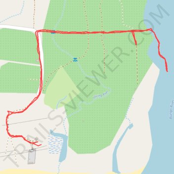
Walk to Bungo River
- Distance: 1.6 mi
- Elevation gain: 33 ft
- Maximum elevation: 52 ft
- Elevation loss: 30 ft
- Minimum elevation: 23 ft
- Moving time: 50 m 34 s
- Moving speed: 1.9 mph
- Maximum speed: 3.6 mph
- Total time: 1 h 9 m
- Global speed: 1.4 mph
Interactive trail map
Thank you for supporting this site ❤️
Make a donation
Make a donation
Gear up for your next adventure:
As an Amazon Associate, this site earns from qualifying purchases at no extra cost to you.
Trail profile
- Distance: 1.6 mi
- Elevation gain: 33 ft
- Maximum elevation: 52 ft
- Elevation loss: 30 ft
- Minimum elevation: 23 ft
- Moving time: 50 m 34 s
- Moving speed: 1.9 mph
- Maximum speed: 3.6 mph
- Total time: 1 h 9 m
- Global speed: 1.4 mph
Thank you for supporting this site ❤️
Make a donation
Make a donation
Gear up for your next adventure:
As an Amazon Associate, this site earns from qualifying purchases at no extra cost to you.
About this trail
Name: Walk to Bungo River trail, distance, elevation, map, profile, GPS track
Start: Mapalad, Aurora, Central Luzon, Philippines (16.12620 121.92266)
End: Mapalad, Aurora, Central Luzon, Philippines (16.12629 121.92254)
Coordinates: 16.12616 121.92145 16.13008 121.92704
Thank you for supporting this site ❤️
Make a donation
Make a donation
Gear up for your next adventure:
As an Amazon Associate, this site earns from qualifying purchases at no extra cost to you.