Munro, Hillwalk, Cuillin, Mhadaidh, Ghreadaidh, Banachdich
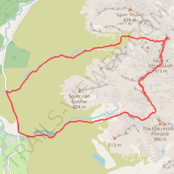
- Distance: 7.7 mi
- Elevation gain: 3,763 ft
- Maximum elevation: 3,068 ft
- Elevation loss: 3,763 ft
- Minimum elevation: 39 ft
- Moving time: 5 h 19 m
- Moving speed: 1.5 mph
- Maximum speed: 3.8 mph
- Total time: 7 h 52 m
- Global speed: 1.0 mph
Interactive trail map
Trail profile
- Distance: 7.7 mi
- Elevation gain: 3,763 ft
- Maximum elevation: 3,068 ft
- Elevation loss: 3,763 ft
- Minimum elevation: 39 ft
- Moving time: 5 h 19 m
- Moving speed: 1.5 mph
- Maximum speed: 3.8 mph
- Total time: 7 h 52 m
- Global speed: 1.0 mph
About this trail
Name: Munro, Hillwalk, Cuillin, Mhadaidh, Ghreadaidh, Banachdich trail, distance, elevation, map, profile, GPS track
Start: Highland, Scotland, IV47 8TA, United Kingdom (57.21995 -6.29295)
End: Highland, Scotland, IV47 8TA, United Kingdom (57.22000 -6.29297)
Coordinates: 57.21026 -6.29303 57.23126 -6.23191