
Stamford Triple - Bald Mountain, Mine Hill and Utsayantha Mountain loop hike
- Distance: 23.4 mi
- Elevation gain: 4,236 ft
- Maximum elevation: 3,186 ft
- Elevation loss: 4,236 ft
- Minimum elevation: 1,749 ft
- Moving time: 4 h 54 m
- Moving speed: 4.8 mph
- Maximum speed: 8.9 mph
- Total time: 5 h 17 m
- Global speed: 4.4 mph
Interactive trail map
Trail profile
- Distance: 23.4 mi
- Elevation gain: 4,236 ft
- Maximum elevation: 3,186 ft
- Elevation loss: 4,236 ft
- Minimum elevation: 1,749 ft
- Moving time: 4 h 54 m
- Moving speed: 4.8 mph
- Maximum speed: 8.9 mph
- Total time: 5 h 17 m
- Global speed: 4.4 mph
About this trail
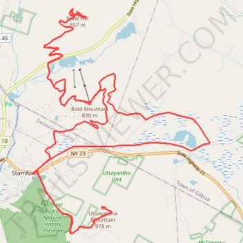
Name: Stamford Triple - Bald Mountain, Mine Hill and Utsayantha Mountain loop hike trail, distance, elevation, map, profile, GPS track
Coordinates: 42.39308 -74.61180 42.44566 -74.55555
Topography: Schoharie County topographic map, elevation, terrain
Other hiking, mountain biking, running and outdoor activity trails
Click on a trail to view its statistics, map and profile.
Bald Mountain loop hike via Headwaters Trails
United States > New York > Delaware County > Village of Stamford
Distance: 8.2 mi • Elevation gain: 1,171 ft • Maximum elevation: 2,703 ft