
Hike from the parking lot to St Louis Canyon
- Distance: 1.3 mi
- Elevation gain: 187 ft
- Maximum elevation: 607 ft
- Elevation loss: 184 ft
- Minimum elevation: 499 ft
- Moving time: 33 m 15 s
- Moving speed: 2.4 mph
- Maximum speed: 5.8 mph
- Total time: 39 m 25 s
- Global speed: 2.0 mph
Interactive trail map
Trail profile
- Distance: 1.3 mi
- Elevation gain: 187 ft
- Maximum elevation: 607 ft
- Elevation loss: 184 ft
- Minimum elevation: 499 ft
- Moving time: 33 m 15 s
- Moving speed: 2.4 mph
- Maximum speed: 5.8 mph
- Total time: 39 m 25 s
- Global speed: 2.0 mph
About this trail
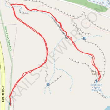
Name: Hike from the parking lot to St Louis Canyon trail, distance, elevation, map, profile, GPS track
Start: East 8th Road, North Utica, LaSalle County, Illinois, 61373, United States (41.31737 -89.00968)
End: East 8th Road, North Utica, LaSalle County, Illinois, 61373, United States (41.31712 -89.00969)
Coordinates: 41.31712 -89.00973 41.32072 -89.00542
Topography: LaSalle County topographic map, elevation, terrain
Other hiking, mountain biking, running and outdoor activity trails
Click on a trail to view its statistics, map and profile.
Saint Louis Canyon Trail in Starved Rock State Park
United States > Illinois > LaSalle County
The Saint Louis Canyon Trail offers hikers a captivating experience with its stunning waterfall and dramatic sandstone formations. As you traverse the well-marked path, you'll encounter a mix of dense forests and the sounds of cascading water, making it a refreshing escape into nature. The trail includes some…
Distance: 2.4 mi • Elevation gain: 279 ft • Maximum elevation: 597 ft