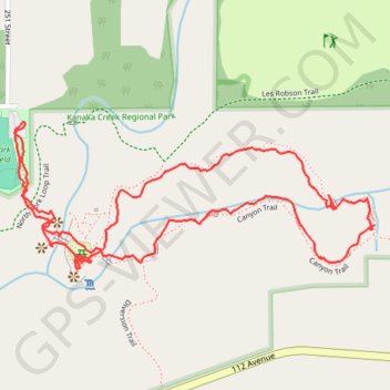
Kanaka Creek - Cliff Falls
Kanaka Creek Regional Park. #Hiking #Loop #KanakaCreek
- Distance: 1.6 mi
- Elevation gain: 148 ft
- Maximum elevation: 299 ft
- Elevation loss: 148 ft
- Minimum elevation: 197 ft
Interactive trail map
Trail profile
- Distance: 1.6 mi
- Elevation gain: 148 ft
- Maximum elevation: 299 ft
- Elevation loss: 148 ft
- Minimum elevation: 197 ft
About this trail
Name: Kanaka Creek - Cliff Falls trail, distance, elevation, map, profile, GPS track
Coordinates: 49.21025 -122.52626 49.21276 -122.51690
Other hiking, mountain biking, running and outdoor activity trails
Click on a trail to view its statistics, map and profile.