
Franey Mountain Trail
- Distance: 9.2 mi
- Elevation gain: 1,588 ft
- Maximum elevation: 1,385 ft
- Elevation loss: 1,640 ft
- Minimum elevation: 66 ft
- Moving time: 3 h 49 m
- Moving speed: 2.4 mph
- Maximum speed: 6.0 mph
- Total time: 5 h 15 m
- Global speed: 1.7 mph
Interactive trail map
Trail profile
- Distance: 9.2 mi
- Elevation gain: 1,588 ft
- Maximum elevation: 1,385 ft
- Elevation loss: 1,640 ft
- Minimum elevation: 66 ft
- Moving time: 3 h 49 m
- Moving speed: 2.4 mph
- Maximum speed: 6.0 mph
- Total time: 5 h 15 m
- Global speed: 1.7 mph
About this trail
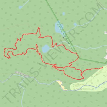
Name: Franey Mountain Trail trail, distance, elevation, map, profile, GPS track
Coordinates: 46.65673 -60.45597 46.67238 -60.41259
Other hiking, mountain biking, running and outdoor activity trails
Click on a trail to view its statistics, map and profile.
Franey Mountain Loop Trail in Cape Breton Highlands National Park
Canada > Nova Scotia > Municipality of Victoria County > Ingonish Centre
Distance: 8.3 mi • Elevation gain: 1,519 ft • Maximum elevation: 1,388 ft
Franey Mountain Loop Trail via MacDougalls Lake
Canada > Nova Scotia > Municipality of Victoria County > Ingonish Centre
Distance: 8.2 mi • Elevation gain: 1,440 ft • Maximum elevation: 1,385 ft