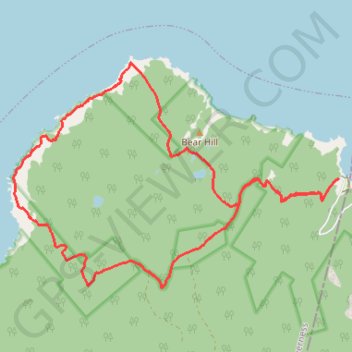
Cape Breton Island - Lowland Cove
Gulf of Saint Lawrence. #Hiking #Loop #CapeBreton #SaintLawrence #Atlantic
- Distance: 9.8 mi
- Elevation gain: 2,165 ft
- Maximum elevation: 863 ft
- Elevation loss: 2,165 ft
- Minimum elevation: 7 ft
Interactive trail map
Trail profile
- Distance: 9.8 mi
- Elevation gain: 2,165 ft
- Maximum elevation: 863 ft
- Elevation loss: 2,165 ft
- Minimum elevation: 7 ft
About this trail
Name: Cape Breton Island - Lowland Cove trail, distance, elevation, map, profile, GPS track
Coordinates: 47.01248 -60.62035 47.04108 -60.55981