Thank you for supporting this site ❤️
Make a donation
Make a donation
Gear up for your next adventure:
As an Amazon Associate, this site earns from qualifying purchases at no extra cost to you.
Redland - Bayview Conservation Area
Interactive trail map
Thank you for supporting this site ❤️
Make a donation
Make a donation
Gear up for your next adventure:
As an Amazon Associate, this site earns from qualifying purchases at no extra cost to you.
Trail profile
- Distance: 13.1 mi
- Elevation gain: 787 ft
- Maximum elevation: 249 ft
- Elevation loss: 784 ft
- Minimum elevation: 23 ft
Thank you for supporting this site ❤️
Make a donation
Make a donation
Gear up for your next adventure:
As an Amazon Associate, this site earns from qualifying purchases at no extra cost to you.
About this trail
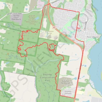
Name: Redland - Bayview Conservation Area trail, distance, elevation, map, profile, GPS track
Coordinates: -27.66870 153.27167 -27.62537 153.30614
Thank you for supporting this site ❤️
Make a donation
Make a donation
Gear up for your next adventure:
As an Amazon Associate, this site earns from qualifying purchases at no extra cost to you.
Other hiking, mountain biking, running and outdoor activity trails
Click on a trail to view its statistics, map and profile.
Bayview Conservation Area Loop
Distance: 13.2 mi • Elevation gain: 968 ft • Maximum elevation: 246 ft