Thank you for supporting this site ❤️
Make a donation
Make a donation
Gear up for your next adventure:
As an Amazon Associate, this site earns from qualifying purchases at no extra cost to you.
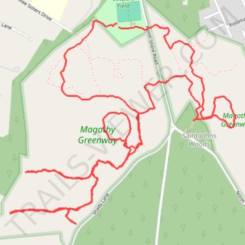
Magothy Greenway Trails
- Distance: 5.6 mi
- Elevation gain: 121 ft
- Maximum elevation: 66 ft
- Elevation loss: 125 ft
- Minimum elevation: 7 ft
- Moving time: 1 h 45 m
- Moving speed: 3.2 mph
- Maximum speed: 12.1 mph
- Total time: 1 h 45 m
- Global speed: 3.2 mph
Interactive trail map
Thank you for supporting this site ❤️
Make a donation
Make a donation
Gear up for your next adventure:
As an Amazon Associate, this site earns from qualifying purchases at no extra cost to you.
Trail profile
- Distance: 5.6 mi
- Elevation gain: 121 ft
- Maximum elevation: 66 ft
- Elevation loss: 125 ft
- Minimum elevation: 7 ft
- Moving time: 1 h 45 m
- Moving speed: 3.2 mph
- Maximum speed: 12.1 mph
- Total time: 1 h 45 m
- Global speed: 3.2 mph
Thank you for supporting this site ❤️
Make a donation
Make a donation
Gear up for your next adventure:
As an Amazon Associate, this site earns from qualifying purchases at no extra cost to you.
About this trail
Name: Magothy Greenway Trails trail, distance, elevation, map, profile, GPS track
Coordinates: 39.09254 -76.49720 39.10397 -76.48091
Topography: Anne Arundel County topographic map, elevation, terrain
Thank you for supporting this site ❤️
Make a donation
Make a donation
Gear up for your next adventure:
As an Amazon Associate, this site earns from qualifying purchases at no extra cost to you.
Other hiking, mountain biking, running and outdoor activity trails
Click on a trail to view its statistics, map and profile.