Thank you for supporting this site ❤️
Make a donation
Make a donation
Gear up for your next adventure:
As an Amazon Associate, this site earns from qualifying purchases at no extra cost to you.
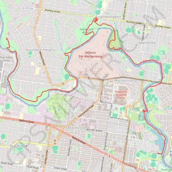
Maribyrnong River
#Hiking #Bike #Maribyrnong #Melbourne
- Distance: 9.2 mi
- Elevation gain: 463 ft
- Maximum elevation: 141 ft
- Elevation loss: 584 ft
- Minimum elevation: 3 ft
Interactive trail map
Thank you for supporting this site ❤️
Make a donation
Make a donation
Gear up for your next adventure:
As an Amazon Associate, this site earns from qualifying purchases at no extra cost to you.
Trail profile
- Distance: 9.2 mi
- Elevation gain: 463 ft
- Maximum elevation: 141 ft
- Elevation loss: 584 ft
- Minimum elevation: 3 ft
Thank you for supporting this site ❤️
Make a donation
Make a donation
Gear up for your next adventure:
As an Amazon Associate, this site earns from qualifying purchases at no extra cost to you.
About this trail
Name: Maribyrnong River trail, distance, elevation, map, profile, GPS track
Coordinates: -37.78889 144.85081 -37.75318 144.90359
Thank you for supporting this site ❤️
Make a donation
Make a donation
Gear up for your next adventure:
As an Amazon Associate, this site earns from qualifying purchases at no extra cost to you.