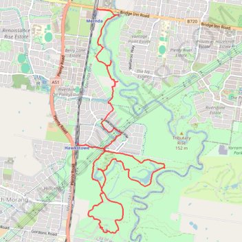
Morang Wetlands
- Distance: 7.8 mi
- Elevation gain: 328 ft
- Maximum elevation: 538 ft
- Elevation loss: 344 ft
- Minimum elevation: 417 ft
- Moving time: 3 h 20 m
- Moving speed: 2.3 mph
- Maximum speed: 3.8 mph
- Total time: 4 h 20 m
- Global speed: 1.8 mph
Interactive trail map
Trail profile
- Distance: 7.8 mi
- Elevation gain: 328 ft
- Maximum elevation: 538 ft
- Elevation loss: 344 ft
- Minimum elevation: 417 ft
- Moving time: 3 h 20 m
- Moving speed: 2.3 mph
- Maximum speed: 3.8 mph
- Total time: 4 h 20 m
- Global speed: 1.8 mph
About this trail
Name: Morang Wetlands trail, distance, elevation, map, profile, GPS track
Coordinates: -37.63703 145.09751 -37.60154 145.11499
Other hiking, mountain biking, running and outdoor activity trails
Click on a trail to view its statistics, map and profile.
Tallarook - Eildon - Hurstbridge
Australia > Victoria > Tallarook
#Bike
Distance: 173.2 mi • Elevation gain: 16,066 ft • Maximum elevation: 2,848 ft
Ashburton to Mernda (cycle)
Australia > Victoria > Melbourne
Distance: 26.2 mi • Elevation gain: 1,286 ft • Maximum elevation: 535 ft