Thank you for supporting this site ❤️
Make a donation
Make a donation
Gear up for your next adventure:
As an Amazon Associate, this site earns from qualifying purchases at no extra cost to you.
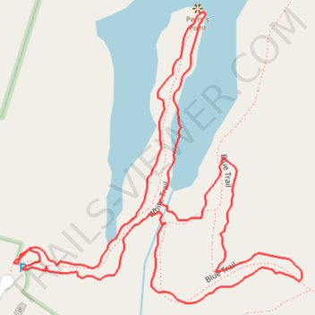
Short loop walk at Opacum Woods via Perry's Point
- Distance: 1.1 mi
- Elevation gain: 43 ft
- Maximum elevation: 686 ft
- Elevation loss: 43 ft
- Minimum elevation: 663 ft
- Moving time: 39 m 40 s
- Moving speed: 1.7 mph
- Maximum speed: 4.5 mph
- Total time: 45 m 3 s
- Global speed: 1.5 mph
Interactive trail map
Thank you for supporting this site ❤️
Make a donation
Make a donation
Gear up for your next adventure:
As an Amazon Associate, this site earns from qualifying purchases at no extra cost to you.
Trail profile
- Distance: 1.1 mi
- Elevation gain: 43 ft
- Maximum elevation: 686 ft
- Elevation loss: 43 ft
- Minimum elevation: 663 ft
- Moving time: 39 m 40 s
- Moving speed: 1.7 mph
- Maximum speed: 4.5 mph
- Total time: 45 m 3 s
- Global speed: 1.5 mph
Thank you for supporting this site ❤️
Make a donation
Make a donation
Gear up for your next adventure:
As an Amazon Associate, this site earns from qualifying purchases at no extra cost to you.
About this trail
Name: Short loop walk at Opacum Woods via Perry's Point trail, distance, elevation, map, profile, GPS track
End: White Trail, Sturbridge, Worcester County, Massachusetts, 01566, United States (42.12489 -72.07780)
Coordinates: 42.12444 -72.07780 42.12768 -72.07348
Topography: Worcester County topographic map, elevation, terrain
Thank you for supporting this site ❤️
Make a donation
Make a donation
Gear up for your next adventure:
As an Amazon Associate, this site earns from qualifying purchases at no extra cost to you.