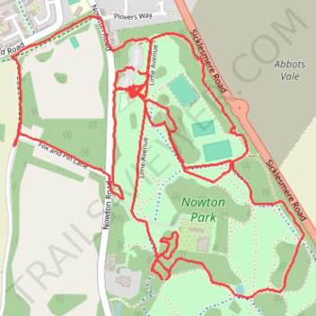
Thank you for supporting this site ❤️
Make a donation
Make a donation
Gear up for your next adventure:
As an Amazon Associate, this site earns from qualifying purchases at no extra cost to you.
Nowton Park Trails
- Distance: 4.5 mi
- Elevation gain: 230 ft
- Maximum elevation: 223 ft
- Elevation loss: 226 ft
- Minimum elevation: 154 ft
- Moving time: 1 h 42 m
- Moving speed: 2.6 mph
- Maximum speed: 12.0 mph
- Total time: 1 h 46 m
- Global speed: 2.5 mph
Interactive trail map
Thank you for supporting this site ❤️
Make a donation
Make a donation
Gear up for your next adventure:
As an Amazon Associate, this site earns from qualifying purchases at no extra cost to you.
Trail profile
- Distance: 4.5 mi
- Elevation gain: 230 ft
- Maximum elevation: 223 ft
- Elevation loss: 226 ft
- Minimum elevation: 154 ft
- Moving time: 1 h 42 m
- Moving speed: 2.6 mph
- Maximum speed: 12.0 mph
- Total time: 1 h 46 m
- Global speed: 2.5 mph
Thank you for supporting this site ❤️
Make a donation
Make a donation
Gear up for your next adventure:
As an Amazon Associate, this site earns from qualifying purchases at no extra cost to you.
About this trail
Name: Nowton Park Trails trail, distance, elevation, map, profile, GPS track
Coordinates: 52.21963 0.72320 52.22835 0.73791
Thank you for supporting this site ❤️
Make a donation
Make a donation
Gear up for your next adventure:
As an Amazon Associate, this site earns from qualifying purchases at no extra cost to you.