Marathon des Alpes-Maritimes Nice - Cannes
- Distance: 26.5 mi
- Elevation gain: 807 ft
- Maximum elevation: 112 ft
- Elevation loss: 820 ft
- Minimum elevation: 0 ft
Interactive trail map
Trail profile
- Distance: 26.5 mi
- Elevation gain: 807 ft
- Maximum elevation: 112 ft
- Elevation loss: 820 ft
- Minimum elevation: 0 ft
About this trail
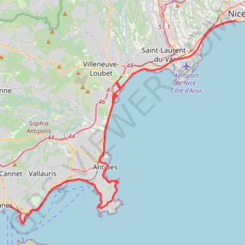
Name: Marathon des Alpes-Maritimes Nice - Cannes trail, distance, elevation, map, profile, GPS track
Coordinates: 43.53662 7.02275 43.69503 7.26720
Other hiking, mountain biking, running and outdoor activity trails
Click on a trail to view its statistics, map and profile.
1 LUCENA - MONTPELLIER
Distance: 1,842.0 mi • Elevation gain: 96,785 ft • Maximum elevation: 3,438 ft
PT23DS2 Lörrach → Cadaqués
Germany > Baden-Württemberg > Landkreis Lörrach > Lörrach (Kernstadt)
Distance: 652.9 mi • Elevation gain: 43,077 ft • Maximum elevation: 4,938 ft
Mougins - Parc de la Valmasque
France > Provence-Alpes-Côte d'Azur > Maritime Alps > Valbonne
Distance: 3.6 mi • Elevation gain: 430 ft • Maximum elevation: 453 ft
Morning ride-12476384
France > Provence-Alpes-Côte d'Azur > Maritime Alps > Nice
Distance: 106.4 mi • Elevation gain: 12,503 ft • Maximum elevation: 3,924 ft