Thank you for supporting this site ❤️
Make a donation
Make a donation
Gear up for your next adventure:
As an Amazon Associate, this site earns from qualifying purchases at no extra cost to you.
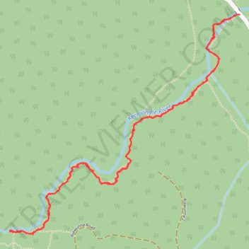
Kermandie Falls Track from Oigles Road
- Distance: 3.9 mi
- Elevation gain: 833 ft
- Maximum elevation: 1,066 ft
- Elevation loss: 843 ft
- Minimum elevation: 384 ft
- Moving time: 2 h 43 m
- Moving speed: 1.4 mph
- Maximum speed: 3.0 mph
- Total time: 3 h 11 m
- Global speed: 1.2 mph
Interactive trail map
Thank you for supporting this site ❤️
Make a donation
Make a donation
Gear up for your next adventure:
As an Amazon Associate, this site earns from qualifying purchases at no extra cost to you.
Trail profile
- Distance: 3.9 mi
- Elevation gain: 833 ft
- Maximum elevation: 1,066 ft
- Elevation loss: 843 ft
- Minimum elevation: 384 ft
- Moving time: 2 h 43 m
- Moving speed: 1.4 mph
- Maximum speed: 3.0 mph
- Total time: 3 h 11 m
- Global speed: 1.2 mph
Thank you for supporting this site ❤️
Make a donation
Make a donation
Gear up for your next adventure:
As an Amazon Associate, this site earns from qualifying purchases at no extra cost to you.
About this trail
Name: Kermandie Falls Track from Oigles Road trail, distance, elevation, map, profile, GPS track
Start: Kermandie Falls Trail, Geeveston, Tasmania, 7116, Australia (-43.18563 146.87845)
End: Oigles Road, Geeveston, Tasmania, 7116, Australia (-43.18552 146.87880)
Coordinates: -43.19864 146.86004 -43.18551 146.87887
Thank you for supporting this site ❤️
Make a donation
Make a donation
Gear up for your next adventure:
As an Amazon Associate, this site earns from qualifying purchases at no extra cost to you.