Thank you for supporting this site ❤️
Make a donation
Make a donation
Gear up for your next adventure:
As an Amazon Associate, this site earns from qualifying purchases at no extra cost to you.
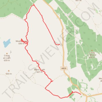
Meall Dearg explore
- Distance: 8.1 mi
- Elevation gain: 1,726 ft
- Maximum elevation: 2,251 ft
- Elevation loss: 1,549 ft
- Minimum elevation: 866 ft
Interactive trail map
Thank you for supporting this site ❤️
Make a donation
Make a donation
Gear up for your next adventure:
As an Amazon Associate, this site earns from qualifying purchases at no extra cost to you.
Trail profile
- Distance: 8.1 mi
- Elevation gain: 1,726 ft
- Maximum elevation: 2,251 ft
- Elevation loss: 1,549 ft
- Minimum elevation: 866 ft
Thank you for supporting this site ❤️
Make a donation
Make a donation
Gear up for your next adventure:
As an Amazon Associate, this site earns from qualifying purchases at no extra cost to you.
About this trail
Name: Meall Dearg explore trail, distance, elevation, map, profile, GPS track
Start: A826, Perth and Kinross, Scotland, PH8 0EB, United Kingdom (56.52640 -3.76229)
End: A826, Perth and Kinross, Scotland, PH8 0EB, United Kingdom (56.54985 -3.78016)
Coordinates: 56.52472 -3.81289 56.56868 -3.76229
Thank you for supporting this site ❤️
Make a donation
Make a donation
Gear up for your next adventure:
As an Amazon Associate, this site earns from qualifying purchases at no extra cost to you.