Thank you for supporting this site ❤️
Make a donation
Make a donation
Gear up for your next adventure:
As an Amazon Associate, this site earns from qualifying purchases at no extra cost to you.
AbN25
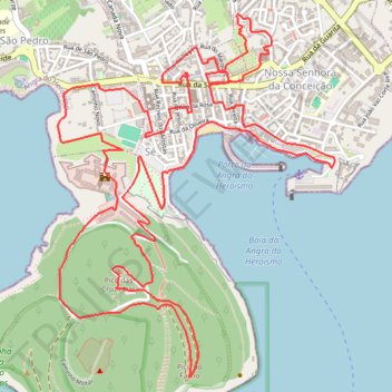
- Distance: 6.8 mi
- Elevation gain: 1,194 ft
- Maximum elevation: 630 ft
- Elevation loss: 1,194 ft
- Minimum elevation: -7 ft
- Moving time: 1 h 8 m
- Moving speed: 5.9 mph
- Maximum speed: 11.3 mph
- Total time: 1 h 8 m
- Global speed: 5.9 mph
Interactive trail map
Thank you for supporting this site ❤️
Make a donation
Make a donation
Gear up for your next adventure:
As an Amazon Associate, this site earns from qualifying purchases at no extra cost to you.
Trail profile
- Distance: 6.8 mi
- Elevation gain: 1,194 ft
- Maximum elevation: 630 ft
- Elevation loss: 1,194 ft
- Minimum elevation: -7 ft
- Moving time: 1 h 8 m
- Moving speed: 5.9 mph
- Maximum speed: 11.3 mph
- Total time: 1 h 8 m
- Global speed: 5.9 mph
Thank you for supporting this site ❤️
Make a donation
Make a donation
Gear up for your next adventure:
As an Amazon Associate, this site earns from qualifying purchases at no extra cost to you.
About this trail
Name: AbN25 trail, distance, elevation, map, profile, GPS track
End: Rua do Marquês, Angra (Sé), Angra do Heroísmo, Azores, 9700-201, Portugal (38.65588 -27.21891)
Coordinates: 38.64240 -27.22894 38.65900 -27.21272
Thank you for supporting this site ❤️
Make a donation
Make a donation
Gear up for your next adventure:
As an Amazon Associate, this site earns from qualifying purchases at no extra cost to you.