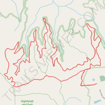
Highlands and Fork Lodge Trail System loop hike
- Distance: 8.8 mi
- Elevation gain: 1,073 ft
- Maximum elevation: 1,732 ft
- Elevation loss: 1,073 ft
- Minimum elevation: 1,421 ft
- Moving time: 2 h 35 m
- Moving speed: 3.4 mph
- Maximum speed: 5.2 mph
- Total time: 2 h 41 m
- Global speed: 3.3 mph
Interactive trail map
Trail profile
- Distance: 8.8 mi
- Elevation gain: 1,073 ft
- Maximum elevation: 1,732 ft
- Elevation loss: 1,073 ft
- Minimum elevation: 1,421 ft
- Moving time: 2 h 35 m
- Moving speed: 3.4 mph
- Maximum speed: 5.2 mph
- Total time: 2 h 41 m
- Global speed: 3.3 mph
About this trail
Name: Highlands and Fork Lodge Trail System loop hike trail, distance, elevation, map, profile, GPS track
Coordinates: 36.51311 -84.85220 36.52573 -84.83010
Topography: Fentress County topographic map, elevation, terrain