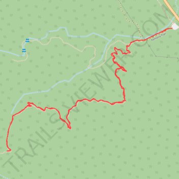
Ramona Trail
Riverside County Hiking
- Distance: 3.3 mi
- Elevation gain: 823 ft
- Maximum elevation: 5,256 ft
- Elevation loss: 820 ft
- Minimum elevation: 4,511 ft
- Moving time: 1 h 23 m
- Moving speed: 2.4 mph
- Maximum speed: 3.3 mph
- Total time: 1 h 27 m
- Global speed: 2.3 mph
Interactive trail map
Trail profile
- Distance: 3.3 mi
- Elevation gain: 823 ft
- Maximum elevation: 5,256 ft
- Elevation loss: 820 ft
- Minimum elevation: 4,511 ft
- Moving time: 1 h 23 m
- Moving speed: 2.4 mph
- Maximum speed: 3.3 mph
- Total time: 1 h 27 m
- Global speed: 2.3 mph
About this trail
Name: Ramona Trail trail, distance, elevation, map, profile, GPS track
Start: Ramona Trail, Riverside County, California, 92361, United States (33.62101 -116.63462)
End: Ramona Trail, Riverside County, California, 92361, United States (33.62107 -116.63426)
Coordinates: 33.61345 -116.64659 33.62107 -116.63426
Topography: Riverside County topographic map, elevation, terrain
Other hiking, mountain biking, running and outdoor activity trails
Click on a trail to view its statistics, map and profile.
Pacific Crest Trail (PCT) through San Bernardino Forest and Santa Rosa and San Jacinto Mountains
United States > California > Riverside County
Hike from Bull Canyon Parking to Snow Creek along the Pacific Crest National Scenic Trail via Lion Peak, Pyramid Peak, Cedar Spring, Palm View Peak, Fobes Saddle, Spitler Peak, Apache Peak, Apache Spring, Antsell Rock, South Peak, Red Tahquitz, Tahquitz Meadow, Powderbox Spring, Middle Spring, Jolley Spring,…
Distance: 59.0 mi • Elevation gain: 13,064 ft • Maximum elevation: 8,980 ft