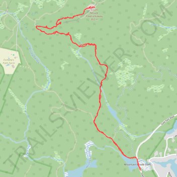
South Mount Pawtuckaway via Mountain Trail and South Ridge Trail
- Distance: 5.8 mi
- Elevation gain: 827 ft
- Maximum elevation: 860 ft
- Elevation loss: 827 ft
- Minimum elevation: 259 ft
- Moving time: 2 h 59 m
- Moving speed: 1.9 mph
- Maximum speed: 26.5 mph
- Total time: 4 h 16 m
- Global speed: 1.4 mph
Interactive trail map
Trail profile
- Distance: 5.8 mi
- Elevation gain: 827 ft
- Maximum elevation: 860 ft
- Elevation loss: 827 ft
- Minimum elevation: 259 ft
- Moving time: 2 h 59 m
- Moving speed: 1.9 mph
- Maximum speed: 26.5 mph
- Total time: 4 h 16 m
- Global speed: 1.4 mph
About this trail
Name: South Mount Pawtuckaway via Mountain Trail and South Ridge Trail trail, distance, elevation, map, profile, GPS track
Start: State Park Road, Nottingham, Rockingham County, New Hampshire, United States (43.08265 -71.17347)
End: State Park Road, Nottingham, Rockingham County, New Hampshire, United States (43.08253 -71.17336)
Coordinates: 43.08253 -71.19047 43.10201 -71.17336
Topography: Rockingham County topographic map, elevation, terrain
Other hiking, mountain biking, running and outdoor activity trails
Click on a trail to view its statistics, map and profile.
2026-06-23_11-48_Tue
United States > New Hampshire > Hillsborough County > Goffstown > Grasmere
Distance: 43.7 mi • Elevation gain: 2,110 ft • Maximum elevation: 459 ft