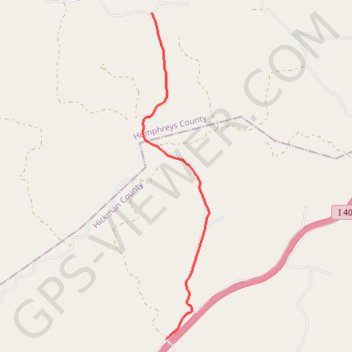
Gravel Route: W Sugar Creek Rd to Caney Hollow Rd
- Distance: 4.5 mi
- Elevation gain: 289 ft
- Maximum elevation: 768 ft
- Elevation loss: 289 ft
- Minimum elevation: 535 ft
Interactive trail map
Trail profile
About this trail
Name: Gravel Route: W Sugar Creek Rd to Caney Hollow Rd trail, distance, elevation, map, profile, GPS track
Coordinates: 35.91731 -87.61198 35.97171 -87.59835
Topography: Humphreys County topographic map, elevation, terrain
Other hiking, mountain biking, running and outdoor activity trails
Click on a trail to view its statistics, map and profile.
Gmaps Pedometer Route
United States > Kentucky > Fulton County > Hickman
Distance: 312.5 mi • Elevation gain: 13,793 ft • Maximum elevation: 1,942 ft
Gravel Route: W Sugar Creek Rd to Gray Branch Rd
United States > Tennessee > Humphreys County > Poplar Grove
Distance: 9.3 mi • Elevation gain: 528 ft • Maximum elevation: 833 ft