Thank you for supporting this site ❤️
Make a donation
Make a donation
Gear up for your next adventure:
As an Amazon Associate, this site earns from qualifying purchases at no extra cost to you.
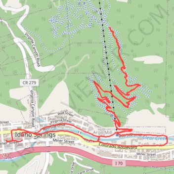
10 Day Jacks trace
- Distance: 6.5 mi
- Elevation gain: 1,194 ft
- Maximum elevation: 8,327 ft
- Elevation loss: 1,191 ft
- Minimum elevation: 7,487 ft
- Moving time: 2 h 11 m
- Moving speed: 3.0 mph
- Maximum speed: 7.6 mph
- Total time: 3 h 18 m
- Global speed: 2.0 mph
Interactive trail map
Thank you for supporting this site ❤️
Make a donation
Make a donation
Gear up for your next adventure:
As an Amazon Associate, this site earns from qualifying purchases at no extra cost to you.
Trail profile
- Distance: 6.5 mi
- Elevation gain: 1,194 ft
- Maximum elevation: 8,327 ft
- Elevation loss: 1,191 ft
- Minimum elevation: 7,487 ft
- Moving time: 2 h 11 m
- Moving speed: 3.0 mph
- Maximum speed: 7.6 mph
- Total time: 3 h 18 m
- Global speed: 2.0 mph
Thank you for supporting this site ❤️
Make a donation
Make a donation
Gear up for your next adventure:
As an Amazon Associate, this site earns from qualifying purchases at no extra cost to you.
About this trail
Name: 10 Day Jacks trace trail, distance, elevation, map, profile, GPS track
Coordinates: 39.74164 -105.51660 39.75109 -105.49995
Topography: Clear Creek County topographic map, elevation, terrain
Thank you for supporting this site ❤️
Make a donation
Make a donation
Gear up for your next adventure:
As an Amazon Associate, this site earns from qualifying purchases at no extra cost to you.