Make a donation
Gear up for your next adventure:
As an Amazon Associate, this site earns from qualifying purchases at no extra cost to you.
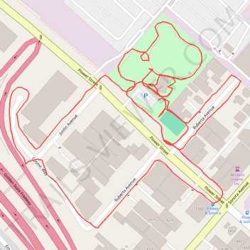
Griffith Manor Park
- Distance: 1.3 mi
- Elevation gain: 20 ft
- Maximum elevation: 499 ft
- Elevation loss: 20 ft
- Minimum elevation: 482 ft
- Moving time: 25 m 29 s
- Moving speed: 3.0 mph
- Maximum speed: 5.3 mph
- Total time: 29 m 54 s
- Global speed: 2.5 mph
Interactive trail map
Make a donation
Gear up for your next adventure:
As an Amazon Associate, this site earns from qualifying purchases at no extra cost to you.
Trail profile
- Distance: 1.3 mi
- Elevation gain: 20 ft
- Maximum elevation: 499 ft
- Elevation loss: 20 ft
- Minimum elevation: 482 ft
- Moving time: 25 m 29 s
- Moving speed: 3.0 mph
- Maximum speed: 5.3 mph
- Total time: 29 m 54 s
- Global speed: 2.5 mph
Make a donation
Gear up for your next adventure:
As an Amazon Associate, this site earns from qualifying purchases at no extra cost to you.
About this trail
Name: Griffith Manor Park trail, distance, elevation, map, profile, GPS track
Start: Flower Street, Glendale, Los Angeles County, California, 91201, United States (34.16425 -118.29247)
End: Flower Street, Glendale, Los Angeles County, California, 91201, United States (34.16429 -118.29244)
Coordinates: 34.16269 -118.29466 34.16520 -118.29126
Topography: Glendale topographic map, elevation, terrain
Make a donation
Gear up for your next adventure:
As an Amazon Associate, this site earns from qualifying purchases at no extra cost to you.