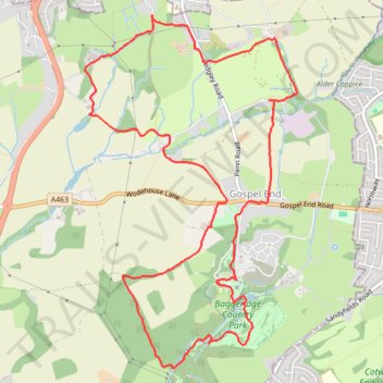
Upper Penn Loop Walk
- Distance: 6.6 mi
- Elevation gain: 646 ft
- Maximum elevation: 591 ft
- Elevation loss: 646 ft
- Minimum elevation: 381 ft
- Moving time: 2 h 50 m
- Moving speed: 2.3 mph
- Maximum speed: 4.3 mph
- Total time: 3 h 28 m
- Global speed: 1.9 mph
Interactive trail map
Trail profile
- Distance: 6.6 mi
- Elevation gain: 646 ft
- Maximum elevation: 591 ft
- Elevation loss: 646 ft
- Minimum elevation: 381 ft
- Moving time: 2 h 50 m
- Moving speed: 2.3 mph
- Maximum speed: 4.3 mph
- Total time: 3 h 28 m
- Global speed: 1.9 mph
About this trail
Name: Upper Penn Loop Walk trail, distance, elevation, map, profile, GPS track
Coordinates: 52.52914 -2.16719 52.55363 -2.14300
Other hiking, mountain biking, running and outdoor activity trails
Click on a trail to view its statistics, map and profile.
Penn Common and Baggeridge Country Park
United Kingdom > England > Staffordshire > South Staffordshire > Gospel End
Paths around Penn and Baggeridge
Distance: 6.6 mi • Elevation gain: 686 ft • Maximum elevation: 591 ft