Thank you for supporting this site ❤️
Make a donation
Make a donation
Gear up for your next adventure:
As an Amazon Associate, this site earns from qualifying purchases at no extra cost to you.
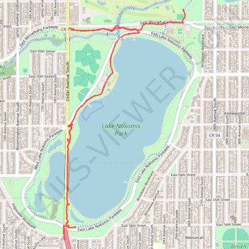
New Nokomis paths
- Distance: 2.7 mi
- Elevation gain: 56 ft
- Maximum elevation: 853 ft
- Elevation loss: 59 ft
- Minimum elevation: 817 ft
- Moving time: 16 m 44 s
- Moving speed: 9.7 mph
- Maximum speed: 17.9 mph
- Total time: 33 m 28 s
- Global speed: 4.8 mph
Interactive trail map
Thank you for supporting this site ❤️
Make a donation
Make a donation
Gear up for your next adventure:
As an Amazon Associate, this site earns from qualifying purchases at no extra cost to you.
Trail profile
- Distance: 2.7 mi
- Elevation gain: 56 ft
- Maximum elevation: 853 ft
- Elevation loss: 59 ft
- Minimum elevation: 817 ft
- Moving time: 16 m 44 s
- Moving speed: 9.7 mph
- Maximum speed: 17.9 mph
- Total time: 33 m 28 s
- Global speed: 4.8 mph
Thank you for supporting this site ❤️
Make a donation
Make a donation
Gear up for your next adventure:
As an Amazon Associate, this site earns from qualifying purchases at no extra cost to you.
About this trail
Name: New Nokomis paths trail, distance, elevation, map, profile, GPS track
Coordinates: 44.90062 -93.24767 44.91731 -93.23525
Topography: Minneapolis topographic map, elevation, terrain
Thank you for supporting this site ❤️
Make a donation
Make a donation
Gear up for your next adventure:
As an Amazon Associate, this site earns from qualifying purchases at no extra cost to you.