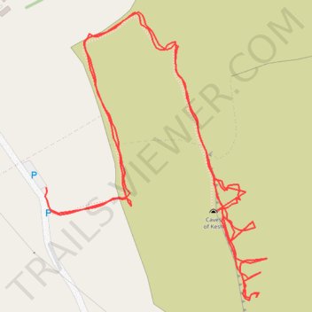
Thank you for supporting this site ❤️
Make a donation
Make a donation
Gear up for your next adventure:
As an Amazon Associate, this site earns from qualifying purchases at no extra cost to you.
The caves of Keash
- Distance: 1.4 mi
- Elevation gain: 709 ft
- Maximum elevation: 673 ft
- Elevation loss: 712 ft
- Minimum elevation: 348 ft
- Moving time: 38 m 24 s
- Moving speed: 2.1 mph
- Maximum speed: 13.9 mph
- Total time: 57 m 57 s
- Global speed: 1.4 mph
Interactive trail map
Thank you for supporting this site ❤️
Make a donation
Make a donation
Gear up for your next adventure:
As an Amazon Associate, this site earns from qualifying purchases at no extra cost to you.
Trail profile
- Distance: 1.4 mi
- Elevation gain: 709 ft
- Maximum elevation: 673 ft
- Elevation loss: 712 ft
- Minimum elevation: 348 ft
- Moving time: 38 m 24 s
- Moving speed: 2.1 mph
- Maximum speed: 13.9 mph
- Total time: 57 m 57 s
- Global speed: 1.4 mph
Thank you for supporting this site ❤️
Make a donation
Make a donation
Gear up for your next adventure:
As an Amazon Associate, this site earns from qualifying purchases at no extra cost to you.
About this trail
Name: The caves of Keash trail, distance, elevation, map, profile, GPS track
Coordinates: 54.05724 -8.45352 54.06041 -8.44937
Thank you for supporting this site ❤️
Make a donation
Make a donation
Gear up for your next adventure:
As an Amazon Associate, this site earns from qualifying purchases at no extra cost to you.