Thank you for supporting this site ❤️
Make a donation
Make a donation
Gear up for your next adventure:
As an Amazon Associate, this site earns from qualifying purchases at no extra cost to you.
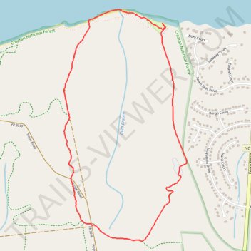
Pine Cliff Loop - Croatan National Forest
- Distance: 3.7 mi
- Elevation gain: 89 ft
- Maximum elevation: 49 ft
- Elevation loss: 89 ft
- Minimum elevation: 10 ft
- Moving time: 1 h 22 m
- Moving speed: 2.7 mph
- Maximum speed: 5.9 mph
- Total time: 1 h 32 m
- Global speed: 2.4 mph
Interactive trail map
Thank you for supporting this site ❤️
Make a donation
Make a donation
Gear up for your next adventure:
As an Amazon Associate, this site earns from qualifying purchases at no extra cost to you.
Trail profile
- Distance: 3.7 mi
- Elevation gain: 89 ft
- Maximum elevation: 49 ft
- Elevation loss: 89 ft
- Minimum elevation: 10 ft
- Moving time: 1 h 22 m
- Moving speed: 2.7 mph
- Maximum speed: 5.9 mph
- Total time: 1 h 32 m
- Global speed: 2.4 mph
Thank you for supporting this site ❤️
Make a donation
Make a donation
Gear up for your next adventure:
As an Amazon Associate, this site earns from qualifying purchases at no extra cost to you.
About this trail
Name: Pine Cliff Loop - Croatan National Forest trail, distance, elevation, map, profile, GPS track
Start: Foster Trail, Craven County, North Carolina, United States (34.92655 -76.82042)
End: Foster Trail, Craven County, North Carolina, United States (34.92653 -76.82042)
Coordinates: 34.92095 -76.83222 34.94053 -76.81958
Topography: Craven County topographic map, elevation, terrain
Thank you for supporting this site ❤️
Make a donation
Make a donation
Gear up for your next adventure:
As an Amazon Associate, this site earns from qualifying purchases at no extra cost to you.