
Verde Divide Trail: West Side up to Little Bean Peak
- Distance: 3.0 mi
- Elevation gain: 741 ft
- Maximum elevation: 6,335 ft
- Elevation loss: 167 ft
- Minimum elevation: 5,679 ft
- Moving time: 1 h 22 m
- Moving speed: 2.2 mph
- Maximum speed: 3.7 mph
- Total time: 1 h 32 m
- Global speed: 2.0 mph
Interactive trail map
Trail profile
- Distance: 3.0 mi
- Elevation gain: 741 ft
- Maximum elevation: 6,335 ft
- Elevation loss: 167 ft
- Minimum elevation: 5,679 ft
- Moving time: 1 h 22 m
- Moving speed: 2.2 mph
- Maximum speed: 3.7 mph
- Total time: 1 h 32 m
- Global speed: 2.0 mph
About this trail
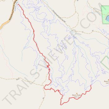
Name: Verde Divide Trail: West Side up to Little Bean Peak trail, distance, elevation, map, profile, GPS track
Start: Ponderosa Trail #382, Yavapai County, Arizona, United States (34.50169 -112.48025)
End: Bean D'Huez, Yavapai County, Arizona, 86301, United States (34.48461 -112.46145)
Coordinates: 34.48033 -112.48030 34.50169 -112.46145
Topography: Yavapai County topographic map, elevation, terrain
Other hiking, mountain biking, running and outdoor activity trails
Click on a trail to view its statistics, map and profile.
Refried Beans - Blue downhill, biker only
United States > Arizona > Yavapai County
Distance: 0.8 mi • Elevation gain: 141 ft • Maximum elevation: 5,899 ft
Bean D'Huez #45
United States > Arizona > Yavapai County
Downhill, bikes only trail
Distance: 0.8 mi • Elevation gain: 259 ft • Maximum elevation: 6,302 ft
Cool Beans #26
United States > Arizona > Yavapai County
Blue downhill, bikes only trail
Distance: 2.7 mi • Elevation gain: 161 ft • Maximum elevation: 6,158 ft
Butter Bean - Blue downhill, biker only
United States > Arizona > Yavapai County
Distance: 1.0 mi • Elevation gain: 0 ft • Maximum elevation: 6,145 ft
Limey Bean #23
United States > Arizona > Yavapai County
Blue climbing trail
Distance: 1.6 mi • Elevation gain: 367 ft • Maximum elevation: 6,122 ft
Jelly Bean #25
United States > Arizona > Yavapai County
Blue downhill, bikes only trail
Distance: 1.2 mi • Elevation gain: 16 ft • Maximum elevation: 6,115 ft
Supreme Bean #36
United States > Arizona > Yavapai County
Downhill, bikes only trail
Distance: 1.5 mi • Elevation gain: 92 ft • Maximum elevation: 6,312 ft
Green Beans #7
United States > Arizona > Yavapai County
Green climbing trail
Distance: 0.9 mi • Elevation gain: 230 ft • Maximum elevation: 5,837 ft