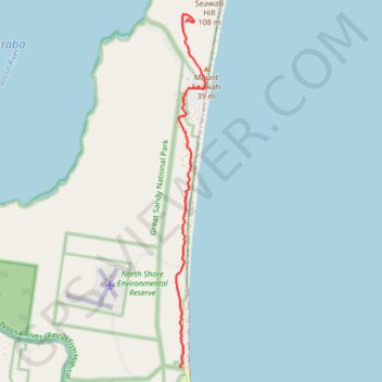
Mount Seawah - Lake Cootharaba
Interactive trail map
Trail profile
- Distance: 5.8 mi
- Elevation gain: 472 ft
- Maximum elevation: 272 ft
- Elevation loss: 253 ft
- Minimum elevation: 3 ft
About this trail
Name: Mount Seawah - Lake Cootharaba trail, distance, elevation, map, profile, GPS track
End: Mt Seawah Track, Noosa North Shore, Noosa Shire, Queensland, Australia (-26.26212 153.06176)
Coordinates: -26.32990 153.05977 -26.26063 153.06599
Other hiking, mountain biking, running and outdoor activity trails
Click on a trail to view its statistics, map and profile.