Import a GPX file

Kyogle - Peacock Creek - Bungdoozle - Iron Pot Creek - Sherwood Lookout

Richmond Range National Park. Toonumbar National Park. #Bike #Loop #Richmond #Toonumbar

  • Distance: 79.2 mi
  • Elevation gain: 10,564 ft
  • Maximum elevation: 2,605 ft
  • Elevation loss: 10,564 ft
  • Minimum elevation: 177 ft

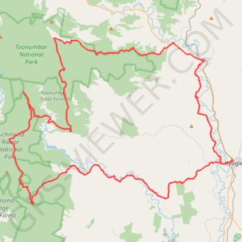
Interactive trail map

Trail profile

  • Distance: 79.2 mi
  • Elevation gain: 10,564 ft
  • Maximum elevation: 2,605 ft
  • Elevation loss: 10,564 ft
  • Minimum elevation: 177 ft

About this trail

Name: Kyogle - Peacock Creek - Bungdoozle - Iron Pot Creek - Sherwood Lookout trail, distance, elevation, map, profile, GPS track

Start: 61, Ettrick Street, Kyogle, Kyogle Council, New South Wales, 2474, Australia (-28.61873 153.00230)

End: 59, Ettrick Street, Kyogle, Kyogle Council, New South Wales, 2474, Australia (-28.61874 153.00210)

Coordinates: -28.66842 152.70753 -28.47723 153.00246

Gear up for your next adventure:

👖Convertible Hiking Pants - Versatile zip-off pants for changing altitudes and temperatures
🧥Waterproof Jacket for Hiking - Breathable and rugged rain jacket for outdoor excursions
🌧️Backpack Rain Cover - Keep gear dry in wet weather
🗺️NatGeo Topo Maps - High-quality waterproof printed topographic maps of US Parks
📌Outdoor GPS Map App - Apps and devices for digital topographic navigation

As an Amazon Associate, this site earns from qualifying purchases at no extra cost to you.