Thank you for supporting this site ❤️
Make a donation
Make a donation
Gear up for your next adventure:
As an Amazon Associate, this site earns from qualifying purchases at no extra cost to you.
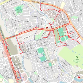
Kellyville - Memorial Ave area
- Distance: 11.5 mi
- Elevation gain: 702 ft
- Maximum elevation: 312 ft
- Elevation loss: 699 ft
- Minimum elevation: 177 ft
- Moving time: 2 h 17 s
- Moving speed: 5.8 mph
- Maximum speed: 16.4 mph
- Total time: 3 h 21 m
- Global speed: 3.4 mph
Interactive trail map
Thank you for supporting this site ❤️
Make a donation
Make a donation
Gear up for your next adventure:
As an Amazon Associate, this site earns from qualifying purchases at no extra cost to you.
Trail profile
- Distance: 11.5 mi
- Elevation gain: 702 ft
- Maximum elevation: 312 ft
- Elevation loss: 699 ft
- Minimum elevation: 177 ft
- Moving time: 2 h 17 s
- Moving speed: 5.8 mph
- Maximum speed: 16.4 mph
- Total time: 3 h 21 m
- Global speed: 3.4 mph
Thank you for supporting this site ❤️
Make a donation
Make a donation
Gear up for your next adventure:
As an Amazon Associate, this site earns from qualifying purchases at no extra cost to you.
About this trail
Name: Kellyville - Memorial Ave area trail, distance, elevation, map, profile, GPS track
Coordinates: -33.73150 150.93819 -33.71050 150.96362
Thank you for supporting this site ❤️
Make a donation
Make a donation
Gear up for your next adventure:
As an Amazon Associate, this site earns from qualifying purchases at no extra cost to you.
Other hiking, mountain biking, running and outdoor activity trails
Click on a trail to view its statistics, map and profile.