Make a donation
Gear up for your next adventure:
As an Amazon Associate, this site earns from qualifying purchases at no extra cost to you.
龍仔坑 象鹿坑 龍巖石澗
Islands District Hike
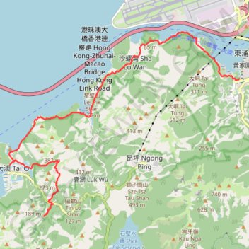
- Distance: 10.5 mi
- Elevation gain: 2,241 ft
- Maximum elevation: 1,043 ft
- Elevation loss: 2,346 ft
- Minimum elevation: -16 ft
- Moving time: 3 h 55 m
- Moving speed: 2.7 mph
- Maximum speed: 15.9 mph
- Total time: 7 h
- Global speed: 1.5 mph
Interactive trail map
Make a donation
Gear up for your next adventure:
As an Amazon Associate, this site earns from qualifying purchases at no extra cost to you.
Trail profile
- Distance: 10.5 mi
- Elevation gain: 2,241 ft
- Maximum elevation: 1,043 ft
- Elevation loss: 2,346 ft
- Minimum elevation: -16 ft
- Moving time: 3 h 55 m
- Moving speed: 2.7 mph
- Maximum speed: 15.9 mph
- Total time: 7 h
- Global speed: 1.5 mph
Make a donation
Gear up for your next adventure:
As an Amazon Associate, this site earns from qualifying purchases at no extra cost to you.
About this trail
Name: 龍仔坑 象鹿坑 龍巖石澗 trail, distance, elevation, map, profile, GPS track
Coordinates: 22.24008 113.86272 22.29256 113.93349
Make a donation
Gear up for your next adventure:
As an Amazon Associate, this site earns from qualifying purchases at no extra cost to you.
Other hiking, mountain biking, running and outdoor activity trails
Click on a trail to view its statistics, map and profile.
20240113Outdoor walk(1)
China > Hong Kong > Islands District > Ngong Ping Village
Distance: 2.5 mi • Elevation gain: 1,795 ft • Maximum elevation: 2,900 ft
2024 4TUL Half Loop Final
China > Hong Kong > Tsuen Wan District > Chuen Lung Village > Chuen Lung Cha Tau Wo
Distance: 55.3 mi • Elevation gain: 7,438 ft • Maximum elevation: 1,755 ft
深坑瀝小路
China > Hong Kong > Islands District > Luk Wu
Distance: 10.3 mi • Elevation gain: 2,382 ft • Maximum elevation: 1,516 ft
羗山東坑 大浪坑左源 羗山北坑左源 凌風石澗
China > Hong Kong > Islands District
Islands District Hike
Distance: 5.9 mi • Elevation gain: 2,457 ft • Maximum elevation: 1,430 ft
Make a donation
Gear up for your next adventure:
As an Amazon Associate, this site earns from qualifying purchases at no extra cost to you.
獅子頭南坑左 獅子頭坑 昂深下源 深石坑
China > Hong Kong > Islands District > Luk Wu
Islands District Hike
Distance: 9.5 mi • Elevation gain: 1,936 ft • Maximum elevation: 1,020 ft
獅子頭山 蓮花台麒麟石 大鐵鎚石 昂坪
China > Hong Kong > Islands District > Luk Wu
Distance: 4.9 mi • Elevation gain: 1,732 ft • Maximum elevation: 2,228 ft