Make a donation
Gear up for your next adventure:
As an Amazon Associate, this site earns from qualifying purchases at no extra cost to you.
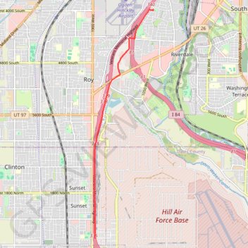
GoMap__2024_09_03__18_55_47
- Distance: 5.0 mi
- Elevation gain: 46 ft
- Maximum elevation: 4,583 ft
- Elevation loss: 253 ft
- Minimum elevation: 4,364 ft
Interactive trail map
Make a donation
Gear up for your next adventure:
As an Amazon Associate, this site earns from qualifying purchases at no extra cost to you.
Trail profile
- Distance: 5.0 mi
- Elevation gain: 46 ft
- Maximum elevation: 4,583 ft
- Elevation loss: 253 ft
- Minimum elevation: 4,364 ft
Make a donation
Gear up for your next adventure:
As an Amazon Associate, this site earns from qualifying purchases at no extra cost to you.
About this trail
Name: GoMap__2024_09_03__18_55_47 trail, distance, elevation, map, profile, GPS track
Start: Veterans Memorial Highway, Sunset, Davis County, Utah, 84015, United States (41.12705 -112.02505)
End: Parker Drive, Riverdale, Weber County, Utah, 84401, United States (41.19095 -112.00330)
Coordinates: 41.12705 -112.02515 41.19104 -112.00326
Topography: Davis County topographic map, elevation, terrain
Make a donation
Gear up for your next adventure:
As an Amazon Associate, this site earns from qualifying purchases at no extra cost to you.