Thank you for supporting this site ❤️
Make a donation
Make a donation
Gear up for your next adventure:
As an Amazon Associate, this site earns from qualifying purchases at no extra cost to you.
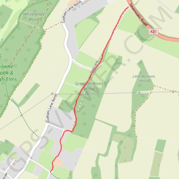
Snag Lane, Green St Green, as walked
- Distance: 1.0 mi
- Elevation gain: 217 ft
- Maximum elevation: 486 ft
- Elevation loss: 7 ft
- Minimum elevation: 269 ft
- Moving time: 23 m 1 s
- Moving speed: 2.6 mph
- Maximum speed: 6.5 mph
- Total time: 23 m 1 s
- Global speed: 2.6 mph
Interactive trail map
Thank you for supporting this site ❤️
Make a donation
Make a donation
Gear up for your next adventure:
As an Amazon Associate, this site earns from qualifying purchases at no extra cost to you.
Trail profile
- Distance: 1.0 mi
- Elevation gain: 217 ft
- Maximum elevation: 486 ft
- Elevation loss: 7 ft
- Minimum elevation: 269 ft
- Moving time: 23 m 1 s
- Moving speed: 2.6 mph
- Maximum speed: 6.5 mph
- Total time: 23 m 1 s
- Global speed: 2.6 mph
Thank you for supporting this site ❤️
Make a donation
Make a donation
Gear up for your next adventure:
As an Amazon Associate, this site earns from qualifying purchases at no extra cost to you.
About this trail
Name: Snag Lane, Green St Green, as walked trail, distance, elevation, map, profile, GPS track
Coordinates: 51.33556 0.08063 51.34785 0.08987
Thank you for supporting this site ❤️
Make a donation
Make a donation
Gear up for your next adventure:
As an Amazon Associate, this site earns from qualifying purchases at no extra cost to you.