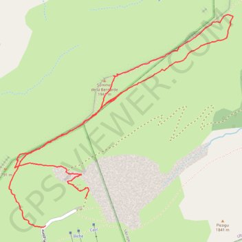
Solheilas - Vauplane - Les Crêtes de la Bernarde
- Distance: 4.6 mi
- Elevation gain: 1,516 ft
- Maximum elevation: 6,325 ft
- Elevation loss: 1,585 ft
- Minimum elevation: 5,240 ft
Interactive trail map
Trail profile
- Distance: 4.6 mi
- Elevation gain: 1,516 ft
- Maximum elevation: 6,325 ft
- Elevation loss: 1,585 ft
- Minimum elevation: 5,240 ft
About this trail
Name: Solheilas - Vauplane - Les Crêtes de la Bernarde trail, distance, elevation, map, profile, GPS track
Coordinates: 43.88369 6.62682 43.90058 6.65154
Other hiking, mountain biking, running and outdoor activity trails
Click on a trail to view its statistics, map and profile.
1 LUCENA - MONTPELLIER
Distance: 1,842.0 mi • Elevation gain: 96,785 ft • Maximum elevation: 3,438 ft
PT23DS2 Lörrach → Cadaqués
Germany > Baden-Württemberg > Landkreis Lörrach > Lörrach (Kernstadt)
Distance: 652.9 mi • Elevation gain: 43,077 ft • Maximum elevation: 4,938 ft