Make a donation
Gear up for your next adventure:
As an Amazon Associate, this site earns from qualifying purchases at no extra cost to you.
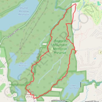
Ragged Mountain Loop via Blue/Red Trail and Metacomet Trail in Ragged Mountain Memorial Preserve
The Ragged Mountain Loop offers a captivating hiking experience, showcasing expansive rocky vistas and stunning views over the Wassel Reservoir. As hikers navigate the moderately challenging terrain, they are treated to sights of vertical cliffs and diverse flora, with opportunities to spot rock climbers along the rugged ledges. The loop also features serene moments, such as passing by vernal pools and even a hidden waterfall, making it a rewarding adventure for both nature enthusiasts and casual hikers alike. #Hiking #Loop #Mountain #Lake #Forest #Nature
- Distance: 5.6 mi
- Elevation gain: 784 ft
- Maximum elevation: 715 ft
- Elevation loss: 787 ft
- Minimum elevation: 233 ft
- Moving time: 1 h 24 m
- Moving speed: 4.0 mph
- Maximum speed: 12.6 mph
- Total time: 1 h 24 m
- Global speed: 4.0 mph
Interactive trail map
Make a donation
Gear up for your next adventure:
As an Amazon Associate, this site earns from qualifying purchases at no extra cost to you.
Trail profile
- Distance: 5.6 mi
- Elevation gain: 784 ft
- Maximum elevation: 715 ft
- Elevation loss: 787 ft
- Minimum elevation: 233 ft
- Moving time: 1 h 24 m
- Moving speed: 4.0 mph
- Maximum speed: 12.6 mph
- Total time: 1 h 24 m
- Global speed: 4.0 mph
Make a donation
Gear up for your next adventure:
As an Amazon Associate, this site earns from qualifying purchases at no extra cost to you.
About this trail
Name: Ragged Mountain Loop via Blue/Red Trail and Metacomet Trail in Ragged Mountain Memorial Preserve trail, distance, elevation, map, profile, GPS track
Coordinates: 41.61471 -72.82345 41.64205 -72.80391
Topography: Capitol Planning Region topographic map, elevation, terrain
Make a donation
Gear up for your next adventure:
As an Amazon Associate, this site earns from qualifying purchases at no extra cost to you.