Tulip Tree and Hidden Pond Loop in Brandywine Creek State Park
The Tulip Tree and Hidden Pond Loop offers a refreshing hike through Delaware’s oldest tulip poplar grove, providing a sense of seclusion amid towering trees and lush understory. Hikers will encounter scenic glimpses of Brandywine Creek as well as the park's historic stone walls from the 19th century, adding a historic touch to the natural surroundings. This moderately challenging loop is ideal for those seeking a mix of open meadows, woodland tranquility, and brief encounters with wildlife along the trail’s quiet, winding paths. #Hiking #Loop #River #Forest #Nature
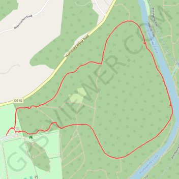
- Distance: 2.3 mi
- Elevation gain: 249 ft
- Maximum elevation: 361 ft
- Elevation loss: 249 ft
- Minimum elevation: 161 ft
- Moving time: 56 m 8 s
- Moving speed: 2.4 mph
- Maximum speed: 17.3 mph
- Total time: 59 m 56 s
- Global speed: 2.3 mph
Interactive trail map
Trail profile
- Distance: 2.3 mi
- Elevation gain: 249 ft
- Maximum elevation: 361 ft
- Elevation loss: 249 ft
- Minimum elevation: 161 ft
- Moving time: 56 m 8 s
- Moving speed: 2.4 mph
- Maximum speed: 17.3 mph
- Total time: 59 m 56 s
- Global speed: 2.3 mph
About this trail
Name: Tulip Tree and Hidden Pond Loop in Brandywine Creek State Park trail, distance, elevation, map, profile, GPS track
Coordinates: 39.80633 -75.57979 39.81466 -75.56670
Topography: New Castle County topographic map, elevation, terrain
Other hiking, mountain biking, running and outdoor activity trails
Click on a trail to view its statistics, map and profile.
Brandywine Creek River Loop via Creekside Trail in Brandywine Creek State Park
United States > Delaware > New Castle County > Winterthur
The Brandywine Creek River Loop offers a delightful hiking experience surrounded by the natural beauty of Brandywine Creek State Park. As you traverse this scenic route, you'll encounter tranquil views of the creek, lush woodlands, and a diverse array of wildlife, making it ideal for nature lovers and…
Distance: 4.7 mi • Elevation gain: 413 ft • Maximum elevation: 361 ft
Rocky Run Loop via Creekside Trail in Brandywine Creek State Park
United States > Delaware > New Castle County
The Rocky Run Loop offers hikers a charming blend of scenic woodlands and peaceful creek views. The trail winds through lush hardwood forests and along the Brandywine Creek, with moments to spot stone walls crafted by early masons and sections lined with old-growth trees, adding a sense of history to the…
Distance: 3.3 mi • Elevation gain: 312 ft • Maximum elevation: 400 ft